Stalwart will construct a railroad spur and 3,400,000 SF of industrial buildings.
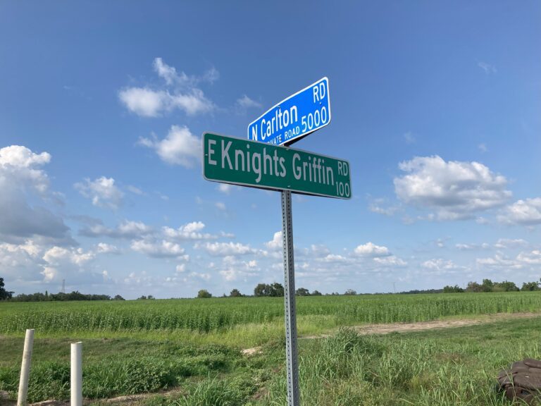
More than 20 years ago, the Eagles Crest development was approved for 437 single family houses, 180 townhouses, 35,000 square feet of commercial space, and a 5,000 square foot community center. The development land is a 410-acre site located north of Knights Griffin Road, west of Bailey Road and east of Paul Buchman Highway. However, the planned development never happened.

On May 12, the City Commission voted to rezone the parcel of land from Plant City Commercial, Residential-4, Natural Preservation (NP), and Hillsborough County Residential-1, to Plant City Industrial. Approximately 370 acres are in Plant City, while the other 40 acres are located in Hillsborough County. The development was renamed the Stalwart Planned Development District. The project will build 3,400,000 square feet of facilities for industrial uses, “excluding any uses dealing with adverse impacts (i.e. dangerous liquids, materials, or gases), bottling plants that require a high volume of water, or any use that creates any nuisance, including unreasonable dust, odors, noise, vibration, or glare such as, but not limited to, recycling facilities and concrete plants.” CSX railroad tracks line the west side of the development, so Stalwart will also contain a rail spur for unloading and loading materials and products specific to the site. A little over 190 acres of the property will be left as open space, and enhanced buffers and screening trees will be placed completely around the development.
In the evaluation of Plant City Planning and Zoning, the development aligns with the Northeast Master Plan to configure the area into a “village,” which the city plans to be a thriving and attractive part of Plant City. The city foresees an environment that is a mixed-use focal point providing a balance of housing, employment and civic uses. So, the area is planned to contain residential clusters, a series of permanent green spaces that keep people from having to travel to get to places to recreate facilities where residents can work and shop, and some agricultural land. Local government policies and zoning are to be set with the aim to preserve and enhance the “hometown charm” and character of Plant City.
City commissioners spent more than an hour of back and forth with the applicant to, among other things, obtain clear assurances about the screening and buffering of the development, make sure construction and trains will not block traffic, and on traffic safety. Roadways leading to entrances will be widened with 500 foot turn lanes. One intersection of concern was an exit point for vehicles leaving the development to turn south on Paul Buchman.
“Is there any plan for signalization at that point….no plan for truck traffic at that spot making a left turn to go southbound?” Kilton asked. A developer representative responded that the decision to place a signal on Paul Buchman is up to FDOT, and the FDOT assessment was that the volume of traffic is not enough to warrant a signal, but if the traffic increases, that would be a future discussion. “I’ve got heartburn over that,” Kilton responded.
In the hearing discussion, at the urging of city commissioners, the developer also agreed to erect barriers that will force trucks to turn west onto Knights Griffin Road. Representatives from CSX described the planned operation, and committed to a condition not to block traffic on Paul Buchman Hwy.
Kilton and city commissioners also questioned the developer’s professional engineer. Normally, the Planning Board standard is to engineer a site like this to handle a 25 year storm event—which is 2.5 inches in 24 hours. If the property has flood plains the standard is to engineer for a 100-year event—equal to 12 inches of rainfall in 24 hours. However, the city commissioners pursued closed basin engineering that would handle a 500-year event, which is 20 inches of rain in 24 hours. The engineer stated that the site will be engineered so that there will be no additional runoff to adjacent properties even during a 500-year storm.
Stalwart facilities will be set back from the property edge by 100 to 150 feet. Trees will be planted so that all of the buildings will be hidden from adjacent properties. Dark-sky lighting will be installed to conform to Planning and Zoning standards and requirements.
“The Stalwart Planned Development is the latest large-scale warehousing and logistics project brought to the city commission for consideration of a map amendment and rezoning request,” City Commissioner Bill Dodson commented. “It consists of 410 acres of which half is set aside for natural wetland and buffering from rural large lot housing. My decision to vote for the Stalwart project is based on the following positive aspects of the project:
• The proposal for development is in compliance with recently adopted city commission policies of development in the northeast.
• There are large buffers and setbacks agreed upon by most large land owners bordering the land use change.
• The project is located along collector and arterial roadways.
• There is far less generated traffic from warehousing land use than an R-4 residential project.
• It is a better economic land use for the community, and a significant new job generator with higher-than-average Hillsborough County wages.
• The developer will pay for a proportionate share of all road improvements and all costs for extension of agreed upon utilities.
• The developer negotiated with contiguous land owners for agreeable protections from land use changes.
The height is a good bit higher than the neighbors’ residential use and height. That would be a limiting factor in consideration of the request for rezoning. However, the developer has organized the buildings internally to the property and arranged for much larger, in-depth landscaping with trees that will grow to 40 feet. This will, in time, effectively deal with the building heights.”